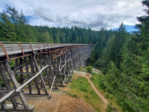
Vancouver Island
Vancouver Island is part of the Canadian province of British Columbia and about 70 miles north of Seattle. This is the largest island in the Pacific Ocean and a completely different place than mainland city of Vancouver. It's about 50 miles wide and 285 miles long and filled with enormous variety to enjoy: rainforests, mountains, lakes, small neighboring islands, miles of beautiful coastline, wildlife and cities. It has a population of about 864,000 and nearly half of those people live in the greater metro Victoria area. For outdoors enthusiasts there are a lot of options to select from and the temperate climate (Victoria is the warmest city in Canada) produces an amazing variety of vegetation, making the entire island very green.

The island is big so we're using the geographic areas from this map to make it easier to see where we have explored the island
Some things we love:
-
Beautiful coastline
-
Variety of terrain
-
Excursions/Tours
-
How green it is everywhere
-
Wandering beautiful Victoria
-
The wildlife
-
Ferry rides
-
Pretty hiking trails
-
Great biking trails
-
Friendly people
-
The flowers
-
The rainforest
-
First People of Canada culture
-
Small islands
-
Mild summer temperatures

Getting here:
There are regular ferries that depart from various locations in B.C. as well as Washington. The major airlines operate into Victoria International Airport and there are also sea planes that fly from Seattle or Vancouver.
Transportation:
The best way to really experience the island is with a car and distances between main geographic areas can be several hours. If you are planning to just visit Victoria you could do that without a car or on a bike.
Costs:
We found this to be a slightly more expensive destination as things just typically were priced higher. However most of what we did was outdoors and free unless it involved a tour or renting something.
Best Time to Visit:
The climate here is temperate and has some of the warmest weather in Canada. Summers tend to average between 70-80 with little rain especially on the southern end of the island. Winters are more typical PNW with clouds and rain.

Helpful Weather Planning App
We have the Ventusky app loaded on our phones and use it all the time as we travel because we can see all sorts of weather information in a map view and by time of day: cloud cover, wind, sun, rain, etc. We found that by checking it we could see what parts of the island were going to have better conditions for something we wanted to do and as a result we had the best weather possible for our outings.
Travel Tips
-
Bring your bike if possible as there are lots of great places to ride and Victoria is very bike friendly.
-
Pack clothing layers that can be easily changed and carried with you as the weather is changeable and varies a lot from sun to shade.
-
Use a bag or purse that has a zipper or can be fastened closed for security.
-
Pack a water bottle unless you want to pay for water.
-
Bring collapsible grocery bags with you or save the ones you get charged, the first time you shop, so you can re-use them.
-
Bring primary and backup credit cards that have no foreign transaction fees and a good exchange rate and then always opt to pay in the local currency instead of dollars because the point-of-sale exchange rate if you pay in USD is consistently bad. We use Chase Sapphire Preferred as our primary credit card, which also provides rental car insurance.
-
Bring a primary and backup debit card with low or no ATM fees. We use Capital One 360 and Charles Schwab, with Capital One as our primary debit card because the app and website are so much easier and quicker. But the Schwab debit card actually reimburses ATM fees worldwide, although you won't see the reimbursement until the end of each billing cycle.
South Vancouver Island
This is the most populous area of the island and includes beautiful Victoria, the capital. This region has several coastal parks, gardens, biking routes, windswept beaches, hiking and lots of tour companies operating various excursions. The ferry terminals to reach not only Vancouver Island but the smaller offshore Gulf islands are here in the south as well as the main airport. There are a number of coastal towns to visit as well as gorgeous interior parks, inlets and natural reserves.

Central Vancouver Island
Filled with lots of coastal towns that run along the eastern side of the island, this region includes parks, camping, beaches, fishing and lots of farmland. The interior part of the island offers beautiful lakes & mountains. And with Nanaimo being a major ferry hub, this area is a jumping off point to explore the Discovery Islands.

North Vancouver Island
This region is more off the beaten path so much less populated. It's filled with rainforest, lots of hiking trails, campsites and small coastal towns. What it's really known for is wildlife as this is the premier area to see whales, bears, eagles and other animals. There are fantastic tours available to experience this.

West Vancouver Island
Known for it's surfing, whale watching, beaches and winter storm watching this area is filled with rainforest and the large Pacific Rim National Park which encompasses 197 square miles. This part of the island receives the most rainfall so being aware of the weather when making plans is important. Ucluelet and Tofino are two popular destinations to experience the area.

Gulf Islands
These are the islands located between Vancouver Island and the mainland of British Columbia in the Strait of Georgia. There are 12 inhabited islands and over 100 smaller ones. Some of these have Mediterranean climates where olive trees can grow! BC Ferries operates a number of ferries on a regular basis to explore this area.


